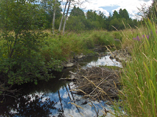
The total watershed area is 33 km² or 3,337 ha and the total watercourse length is 34 km.
Martin Creek North
Martin Creek North is a notable watercourse situated northwest of Bobcaygeon, flowing southward into Sturgeon Lake.The creek's watershed encompasses approximately 33 square kilometers, featuring a total watercourse length of 34 kilometers.The landscape is predominantly covered by coniferous forests, contributing to 71% natural vegetation cover, including 224 hectares of forest interior.
A significant ecological feature within the watershed is the Hawkers Creek Complex, a Provincially Significant Wetland covering 6 hectares.This wetland plays a crucial role in maintaining regional biodiversity, water quality, and flood regulation.
Environmental assessments indicate that the surface water quality of Martin Creek North is rated as good, with a Family Biotic Index (FBI) score of 4.99, reflecting healthy benthic macroinvertebrate communities. Forest conditions within the watershed are rated as excellent, highlighting the area's rich natural heritage.
Understanding the characteristics and environmental conditions of Martin Creek North is essential for effective watershed management and conservation efforts, ensuring the preservation of its ecological integrity and the health of the broader Sturgeon Lake ecosystem.

Watershed characteristics
Learn about the characteristics of the Martin Creek North watershed.
The dominant forest type is coniferous forest including:
- Forest interior: 224 ha
- 71% natural cover
Provincially Significant Wetlands: Hawkers Creek Complex (6 ha)
Environmental conditions
The following grades show the environmental conditions for the Martin Creek North watershed.
| Indicator | Result | Grade | Status |
|
Total phosphorus |
N/A |
N/A |
N/A |
|
Benthic macroinvertebrates |
4.99 (FBI) |
B |
Good |
The surface water quality grade was based on total phosphorous (TP) and/or benthic macroinvertebrates (aquatic insects) family biotic index (FBI). The provincial water quality objective for TP in rivers and streams is 0.03 mg/L and 0.02 mg/L in lakes. These guidelines were set because levels highter than these guildelines provide conditions for nuisance algae and aquatic plant growth. A TP value below 0.03 mg/L (rivers) or 0.02 (lakes) meets the provincial guidelines and is in the B (good) or A (excellent) grade range, while the result for benthic macroinvertebrates must be 5.00 or lower to receive a B (good) or A (very good to excellent) grade.
| Indicator | Area cover | Percent cover | Grade | Status |
|
Forest cover |
20.2 km² |
60.7% |
A |
Excellent |
|
Forest interior |
9.3 km² |
27.9% |
A |
Excellent |
|
Forested riparian cover |
1.3 km² |
61.2% |
A |
Excellent |
The combined forest conditions grade for Martin Creek North is ranked as excellent.
| Indicator | Area cover | Percent cover | Grade | Status |
|
Wetland cover |
9.6 km² |
28.7% |
A |
Excellent |
Contact Us
Kawartha Conservation
277 Kenrei Road
Lindsay, ON K9V 4R1
Tel: 705.328.2271
Fax: 705.328.2286
Subscribe to Receive Updates and Notifications
Stay up to date on flood and low water, news, activities, events, programs and operations by subscribing to updates and the Watershed Watch Newsletter.
