- Water Quality grades for lakes ranged from A to B, with mostly A grades.
- Water quality grades for rivers and streams ranged from B to D, with mostly D grades.
- *E. coli was only measured in the Balsam Lake, Cameron Lake, Pigeon Lake, and Lake Scugog subwatersheds.
- Benthic invertebrate sampling primarily took place in streams flowing through the urban areas of Lindsay, Port Perry, Fenelon Falls, Bobcaygeon, and Omemee. Streams with lower grades generally produced more pollutant-tolerant species such as the aquatic sowbug.
- Due to shift in monitoring objectives, there are various subwatersheds that do not have sufficient data to satisfy the criteria of the Watershed Report Card scoring system.
Watershed Report Cards
In 2012, Conservation Authorities developed a set of guidelines to assist with the standardizing of Watershed Report Cards across the province. Kawartha Conservation monitors the health of natural resources in our watershed and generates a Watershed Report Card every 5 years along with the other 36 Conservation Authorities.
Through the watershed report cards, Kawartha Conservation monitors four resource categories, including surface water quality, groundwater quality, forest conditions and wetland cover, assigning a grade to each category.
Overall, what did we learn about the Kawartha Watershed?
- Grades ranged from A to F, with mostly C grades.
- The Balsam Lake, Cameron Lake, Mariposa Brook, and McLarens Creek subwatersheds received a lower grade in comparison to the 2018 Watershed Report Card due to the loss of forested land caused by different land use pressures.
- Kawartha Conservation’s watershed benefits from 33% forest cover.
- Watersheds with less than 30% forest cover provide limited support to aquatic systems and habitat, which leads to decreased water quality and biodiversity, limited recreational opportunities, and more.
- *Forest grades were derived using 2018 imagery, which was the best available data at the time of publishing but may not reflect present day conditions. Contact Kawartha Conservation to learn more.
- Due to unforeseen equipment malfunctions, 3 of the 10 monitoring wells had insufficient data. Impacted monitoring stations include two wells in the north and south of Durham East Cross Forest, and one in Pontypool.
- Groundwater quality grades for nitrate + nitrite ranged from A to B, with mostly A grades. Levels of nitrate + nitrite met the Ontario Drinking Water Standards, indicating good water quality.
- Groundwater quality grades for chloride ranged from A to F, with mostly A grades. However, chloride levels in some areas are approaching or have exceeded the Canadian Drinking Water Guidelines, suggesting possible groundwater contamination through winter salt application.
- The quality of your private well water may vary from that of the provincial monitoring wells.
- Grades ranged from A to F, with mostly A grades.
- The Cameron Lake and Pigeon Lake subwatersheds received a lower grade in comparison to the 2018 Watershed Report Card due to the loss of wetlands caused by different land use pressures.
- Kawartha Conservation’s watershed benefits from 15.4% wetland cover.
- Watersheds with less than 10% wetland cover are at risk for increased flooding, decreased biodiversity and water quality, which is why it is important to protect and restore wetlands within our region.
- *Wetland grades were derived using 2018 imagery, which was the best available data at the time of publishing but may not reflect present day conditions. Contact Kawartha Conservation to learn more.
Use the interactive watershed map above to take a closer look at the individual lakes and watershed areas. Use the drop down in the top right corner to change between Surface Water Quality, Groundwater Quality, Forest Conditions and Wetland Cover.
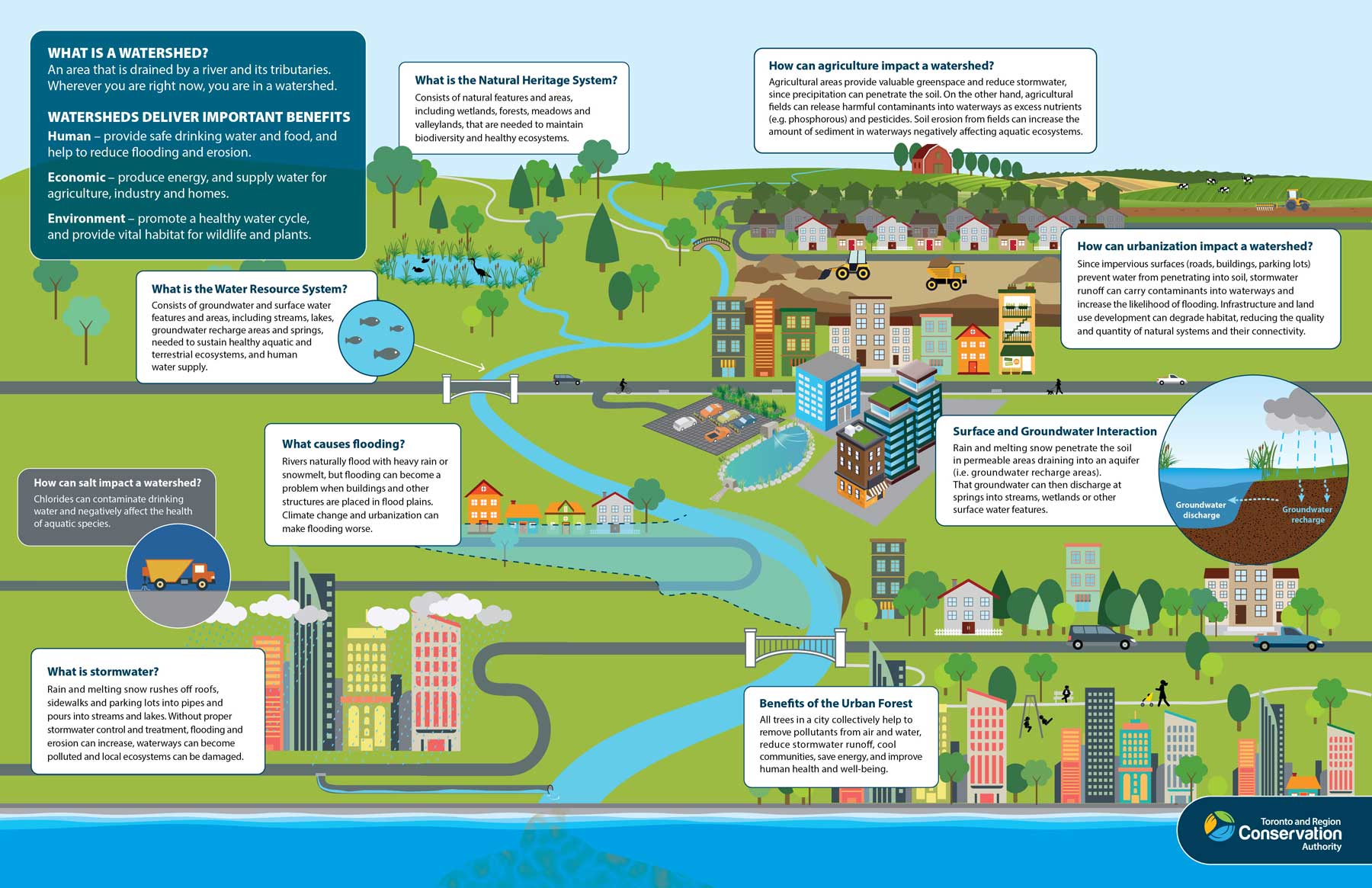
What is a Watershed?
A watershed is the area of land that catches rain and snow and drains or seeps into a marsh, stream, river, lake or groundwater. Watersheds are the collectors, filters, conveyers and storage compartments of our fresh water supply.

* Illustration courtesy of Toronto and Region Conservation Authority
Contact Us
Kawartha Conservation
277 Kenrei Road
Lindsay, ON K9V 4R1
Tel: 705.328.2271
Fax: 705.328.2286
Subscribe to Receive Updates and Notifications
Stay up to date on flood and low water, news, activities, events, programs and operations by subscribing to updates and the Watershed Watch Newsletter.
