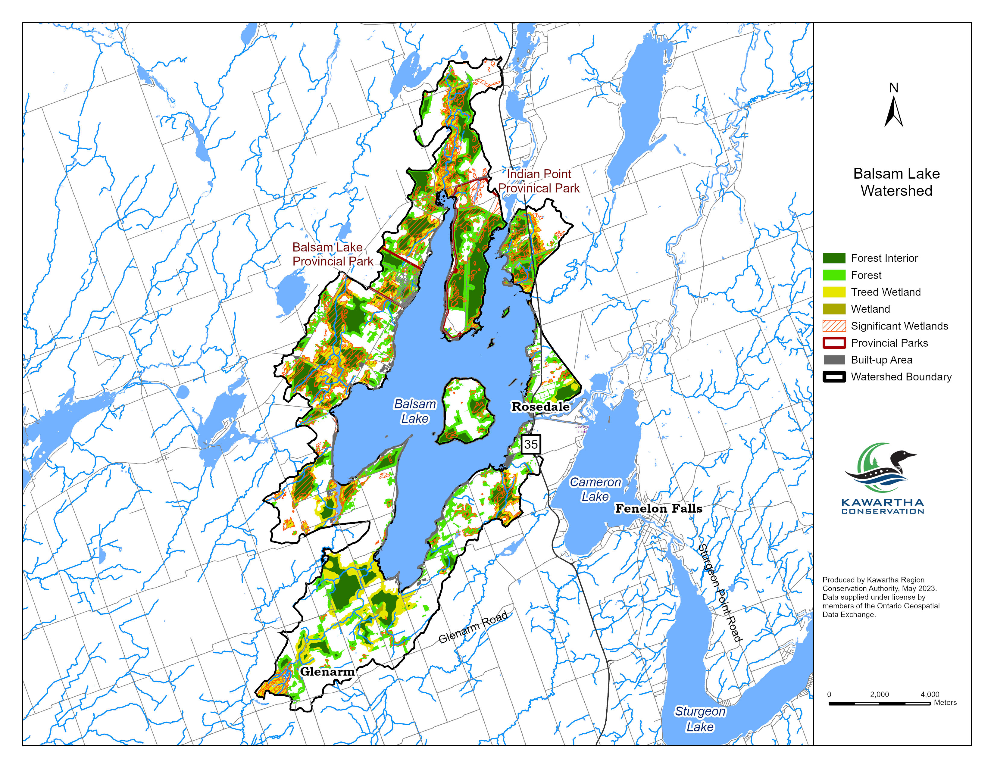
The total watershed area is 115 km² or 11,489 ha and the total lake area is 48 km².
Balsam Lake
Balsam Lake, situated within the Kawartha Conservation watershed, holds the distinction of being the highest point along the Trent-Severn Waterway. Spanning approximately 48 square kilometers, the lake receives water from the Canadian Shield via the Gull River and surrounding streams, contributing to its diverse aquatic ecosystem.
The Balsam Lake watershed encompasses 115 square kilometers, featuring a mix of natural vegetation and significant ecological sites. Notably, the area includes several Provincially Significant Wetlands, such as Balsam Lake South Bay No.42 and Indian Point, which provide essential habitats for various plant and animal species.
Environmental assessments indicate that Balsam Lake maintains excellent surface water quality, with total phosphorus levels meeting provincial guidelines. The surrounding forest conditions are also rated as excellent, reflecting the area's commitment to preserving its natural environment.
For those interested in exploring Balsam Lake and its surroundings, the area offers opportunities for recreational activities such as boating, fishing, and hiking, all while enjoying the scenic beauty of the Kawartha region.
Watershed characteristics
Learn about the characteristics of the Balsam Lake watershed.
The dominant forest type is mixed forest including:
- Forest interior: 1,951 ha
- Forest deep interior: 560 ha
- 52% natural cover
Provincially Significant Wetlands
- Balsam Lake No.14: 183 ha
- Balsam Lake No.15: 12 ha
- Balsam Lake South Bay No.42: 674 ha
- Balsam Lake Wetland: 13 ha
- Corben Creek Wetland: 32 ha
- Grass Creek (Eldon Twp.): 6 ha
- Indian Point: 19 ha
- Pearns Creek: 89 ha
- Staples Creek: 124 ha
Area of Natural and Scientific Interest (ANSI) - Life Science
- Burnt River Mouth Wetlands: 1.44 ha
- Indian Point: 805 ha
Balsam Lake
Lake Health Monitoring Program
Balsam Lake is monitored every two years as part of Kawartha Conservation’s bi-annual Lake Health Monitoring Program. The program brings together information from three areas: water quality and vertical lake profiling, aquatic plants, and shoreline condition. Staff monitor nutrients and other water-quality indicators, measure temperature and dissolved oxygen from the surface to the lake bottom, survey aquatic plant species and abundance, and assess natural and altered shoreline areas. Looking at these indicators together provides a more complete understanding of the lake, helps track changes over time, and informs decisions that support its long-term health.
The current StoryMap presents the results of 2025 water quality monitoring conducted at three locations on Balsam Lake and three tributary locations within the surrounding watershed. It shows that Balsam Lake continues to have generally good water quality, while identifying phosphorus as an ongoing concern and noting localized phosphorus and dissolved oxygen concerns in some tributaries. The StoryMap also explains how future aquatic plant and shoreline monitoring will add to this understanding, with aquatic plants scheduled to be sampled in 2027 and shoreline conditions in 2028.
Subscribe to Receive Updates and Notifications
Stay up to date on flood and low water, news, activities, events, programs and operations by subscribing to updates and the Watershed Watch Newsletter.